


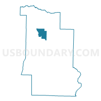
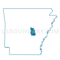
EAGLE Voting District, Lonoke County, Arkansas
About
Outline

Summary
| Unique Area Identifier | 527178 |
| Name | EAGLE Voting District |
| County | Lonoke County |
| State | Arkansas |
| Area (square miles) | 13.91 |
| Land Area (square miles) | 13.36 |
| Water Area (square miles) | 0.55 |
| % of Land Area | 96.04 |
| % of Water Area | 3.96 |
| Latitude of the Internal Point | 34.89199750 |
| Longtitude of the Internal Point | -91.94961330 |
Maps

Graphs
Select a template below for downloading or customizing gragh for EAGLE Voting District, Lonoke County, Arkansas


Neighbors
Neighoring Voting District (by Name) Neighboring Voting District on the Map
- CLEVELAND Voting District, Lonoke County, AR
- FURLOW Voting District, Lonoke County, AR
- GOODRUM Voting District, Lonoke County, AR
- LONOKE RURAL Voting District, Lonoke County, AR
- OAK GROVE Voting District, Lonoke County, AR
Top 10 Neighboring County Subdivision (by Population) Neighboring County Subdivision on the Map
- Lonoke township, Lonoke County, AR (5,191)
- Oak Grove township, Lonoke County, AR (4,154)
- Goodrum township, Lonoke County, AR (2,611)
- Eagle township, Lonoke County, AR (1,719)
- Furlow township, Lonoke County, AR (1,102)
- Cleveland township, Lonoke County, AR (338)